
Kenya leads deployment of AI climate-monitoring payload to space station
ClimCam system aims to deliver near-real-time data on floods, forests and carbon storage across East Africa
By Chemtai Kirui | Nairobi
A Kenyan-led climate monitoring payload docked with the International Space Station on Monday, marking a shift toward using space-based artificial intelligence to track carbon storage, forests and weather patterns across East Africa.
The 3.5-kg “ClimCam” was launched on April 11 at 1341 GMT+3 aboard a SpaceX Falcon 9 rocket as part of Northrop Grumman’s Cygnus NG-24 resupply mission from Cape Canaveral, the Kenya Space Agency said.
It is expected to be installed on the Airbus Bartolomeo platform, attached to the European Columbus module, where it will operate for about a year. The platform provides a stable power supply and high-speed data transmission, allowing continuous monitoring without the limitations of standalone satellites.
The mission, led by the Kenya Space Agency in partnership with the Egyptian Space Agency and the Uganda National Space Programme, is designed to give the region more control over climate data historically sourced from foreign satellites, with officials saying it could deliver near-real-time alerts on floods and crop stress.
The project was selected under a United Nations-backed “Access to Space for All” programme run with Airbus. The payload was assembled and tested in Egypt before undergoing final validation at Airbus facilities in the United States.
“This is about moving from data dependence to data sovereignty,” said Hillary Kipkosgey, Director General of the Kenya Space Agency, in a statement issued after the launch.
ClimCam is designed to capture high-resolution images of ecosystems across East Africa and process them in near real time using onboard machine learning algorithms.
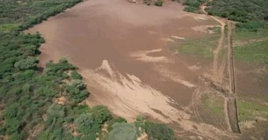
Unlike conventional systems that transmit raw data to Earth for processing — a process that can take days — the payload analyses imagery in orbit. That allows it to detect changes in vegetation, water levels and land use more quickly, providing what officials describe as near-instant climate intelligence.
Positioned roughly 400 kilometres above Earth, the camera will pass over East Africa up to four times a day, generating a steady stream of data on forest cover, biomass and weather patterns.
That frequency is expected to improve early warning systems for floods and droughts in cities such as Nairobi and Kampala, where extreme weather has become more frequent.
Officials say the system could strengthen access to climate finance by improving how carbon storage is measured, with high-resolution data required to verify forest cover and emissions reductions.
At a resolution of about 10 metres, ClimCam can distinguish between small agricultural plots and riparian zones — a level of detail that allows scientists to track forest density and vegetation health more precisely.
That data underpins Monitoring, Reporting and Verification (MRV) systems required for participation in international carbon markets, where countries must demonstrate measurable emissions reductions or carbon absorption.
“Standard satellite data is often too coarse or delayed,” said Charles Mwangi, Director of Space Sector and Technology Development at the Kenya Space Agency. “With higher resolution and faster processing, we can verify carbon sequestration in near real time.”
The project was developed under a joint African framework that splits technical roles across countries. Engineers in Cairo led assembly and testing, while Kenyan teams focused on Earth observation applications and onboard systems. Uganda is expected to support data downlink and ground operations.
Officials say the approach reduces costs while building regional technical capacity, allowing African countries to participate in space research without launching standalone satellites.
The mission also reflects a broader shift in Kenya’s technology sector, which has been dominated by mobile and software innovation.
By developing hardware capable of operating in orbit, officials say the country is moving into more advanced engineering fields, including satellite systems and edge computing.
“This is not just about a camera,” Kipkosgey said. “It is about ensuring African scientists are the primary custodians of African climate intelligence.”
Data from ClimCam will be transmitted to ground stations in Kenya and the wider region before being integrated into national planning systems.
Officials say the data will support environmental monitoring, urban planning and disaster response, feeding into climate adaptation strategies.
The Kenya Space Agency said the mission is intended to support planning and a growing space technology sector by providing locally generated Earth observation data.
The mission comes as governments across the region face growing pressure to respond to floods, droughts and land degradation linked to climate change.
With ClimCam now in orbit, policymakers will, for the first time, have access to high-frequency, locally controlled data to track climate changes as they unfold.